Summit Elevation (m): 2636
Trip Date: Friday, May 25, 2018
Elevation Gain (m): 1250
Round Trip Time (hr): 9.5
Total Trip Distance (km): 23
Quick ‘n Dirty Rating: Class 3 – you fall, you break your leg
Difficulty Notes: Circuitous approach route, feels long for a front range peak. Some complex routefinding on alternate descent. Moderate exposure to the summit.
Technical Rating: SC6; YDS (3rd)
GPS Track: Gaia
Map: Google Maps
On a very warm Friday, May 25, 2018, I finally got to ascend a front-range peak in the Ghost Wilderness that I’ve had on my radar for many years already – Orient Point. Why has it been on my “to-do” list so long? Simple! I’ve been hearing some pretty great things about it from friends and acquaintances over the years. It started for me, when Kerry Vizbar posted a report on the old RMBooks forum back in 2009. Raf and Sonny tried to follow his route a few years later but ended up on a difficult sounding route up the most westerly south ridge instead. Since then I’ve followed trip reports almost every year – usually in Spring – but it simply hasn’t worked out for me. In 2017, Phil and Cornelius went up a slightly different route than I’d heard of before and Phil enjoyed it so much, he offered to repeat it with me this Spring. The stars finally aligned as I got a Friday off work on a perfect day and I headed off to the Ghost Wilderness to see what all the fuss was about. There are two different approaches to the start of the main ATV / horse trails leading towards Orient Point from the Ghost River. See the map below;

As you can see on the map above, even though it seems like the obvious preference for the driving approach would be to drive all the way to the random campsite at center bottom, it’s not quite that straightforward. Firstly, the drive is quite a bit longer with that option. It’s also much sketchier – especially if you’re not a regular off-road driver like myself. Since Phil and Cornelius had done the more direct approach before, we decided to try the longer driving approach this time. We reasoned that at the very least it saved us a bunch of river crossings, since the Ghost River is very braided at the direct crossing and Phil remembered it being quite high at the end of the day.
Driving towards the river, down the infamous “Big Hill” at the end of the Ghost Valley Road, I was a bit nervous to see quite a bit of water in a narrower and faster river channel than I remembered from previous trips across it. I briefly consulted a guy pulling his camper out of the area next to the river (how the heck do people pull huge campers up / down that road?!) and he assured me that many stock trucks had driven across already that week and that the water levels in the river hadn’t been dramatically changing over the days he was camped there. There was nothing to do but drive across at that point! I drove a bit too quickly into the current and splashed water over the hood of my Tacoma but made it through to the other side with no other issues. I resolved to go a bit slower on return – a common rookie mistake that can flood the engine is driving through water too fast. You want enough speed to carry through, but not so much that you create a huge wave that washes back over your hood.
After the river crossing we relaxed a bit and headed towards the start of our hike along a very nice road / track on the gravel flats just west of the main river. Of course, this excellent track didn’t last long. As we headed back towards the river channel, the track slowly deteriorated until we were looking at a very indistinct set of tire tracks heading back into the many flowing river channels of the now-braided Ghost River. This was unexpected. We were expecting a rough 4×4 track alongside the river to the campsite, not one heading right through the river again!

We started following the faint 4×4 track through the riverbed – this time the river was very braided and the flow was much shallower and easier to drive through than the single channel at the bottom of the big hill. At first we could easily ascertain the correct route and pick up hints of tracks here and there, but eventually we found ourselves driving right down a river channel, in the water and unable to clearly find a straightforward path. We had a decision to make. We knew we were only about 1km from the campsite with easy hiking alongside the river on its SW bank. We also knew that we could likely spend quite a bit of time picking our way slowly down the riverbed in the truck, possibly not able find a good route back up the river bank, and necessitating some sort of crossing on foot – exactly what we were trying to avoid with all this extra driving! We made the call to quit fooling around with the approach drive and simply suck up the extra 10-15 minutes walking on the dry riverbank to the start of the horse track / ATV trail.
Already from the approach drive along the riverbank and beneath the hulking NE face of Orient Point, I’d been thinking one thought that would continue to circle my brain for hours to come, “when the heck are we going to start ascending this peak?!”. That may come across negative, and I guess maybe it is a bit. Orient Point has a whole lot going for it, as you’ll see later, but it does have one large thing NOT going for it, IMHO, and that is the long and circuitous approach.
Phil and Cornelius really enjoyed their approach, but their route was slightly more scenic. The spring of 2018 has been pretty bad for ticks – Phil had 16 of them while exploring similar terrain to Orient’s open grassy hills under its east face. Because of the potential tick issue, we decided on the longer and less engaging approach via the South Ghost River – often used for egress from the area. If you’ve done other peaks in the Ghost Wilderness, such as End Mountain or Association Peak, you should expect a similar approach grind for Orient Point. There is one difference with Orient Point’s approach compared with other long approaches, however. Instead of the peak being far off in the distance, Orient Point is right in front (or beside) you the whole time you are “approaching” it – you’re just not actually going towards it for a few hours! There were many moments on approach when I had to look back over my right shoulder to see our objective as we literally walked away from it to my left. With that bit of negativity out of the way, the rest of the day was immensely enjoyable – read on.
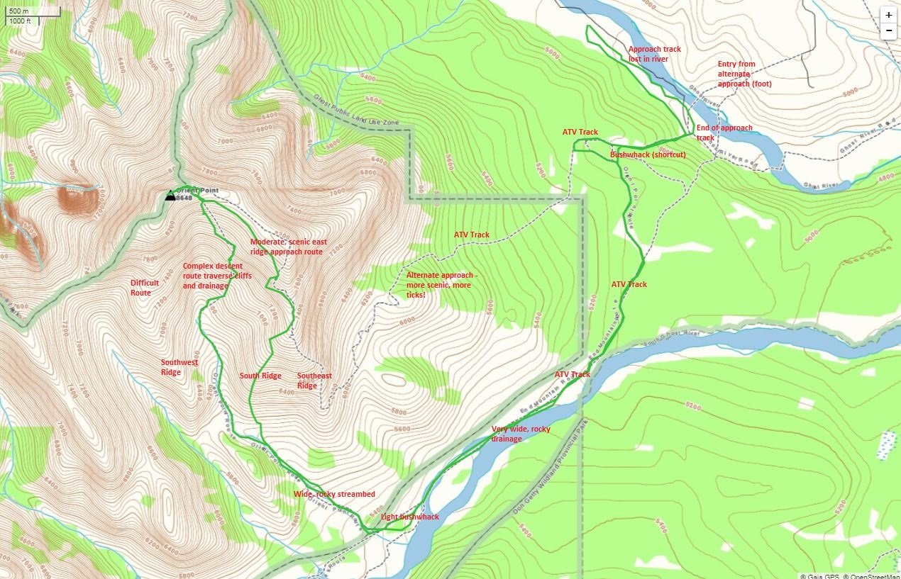
We started out on an obvious ATV / horse track from the backcountry random campsite at the end of the “drivable” section along the Ghost River and almost directly across the river from the more direct driving / approach that Phil and Cornelius used. The rough track followed steeply up a drainage until looping back on itself at the forks for the open hills vs. the South Ghost River approach routes. We somewhat reluctantly turned our backs on Orient Point and headed slightly downhill along the main ATV track, foregoing the open hills and their hordes of wood ticks for the cool forest and it’s Calypso Orchids.
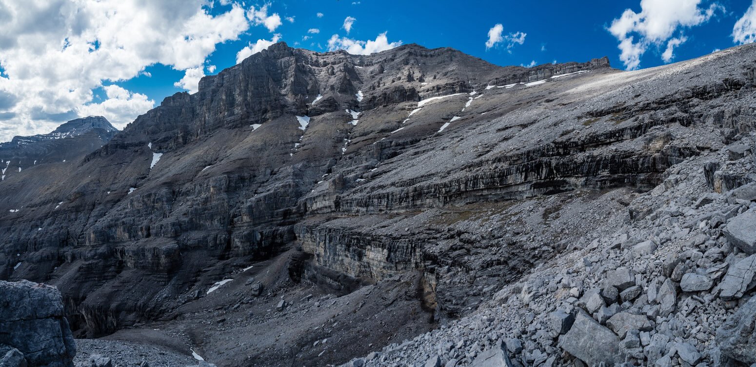
After a short while, navigating obvious trails through light forest, we exited into the very hot and surprisingly dry South Ghost River drainage. Phil remembered a pretty hefty flow a year previous, but all we could find at this point was the odd little trickle coming down the occasional hillside beside the riverbed. A strange development considering the massive amounts of snow we had this past winter and the late Spring. We continued to wrap around the ominous, brooding cliffs on SE aspect of Orient Point via the expansive river drainage until we arrived at another remote backcountry campsite and the start of our final bushwhack approach to the SE drainage that grants scramblers access to the mountain. We could have avoided the bushwhack by simply hiking a bit further up the South Ghost River to the side drainage but we saw a faint track and followed it.

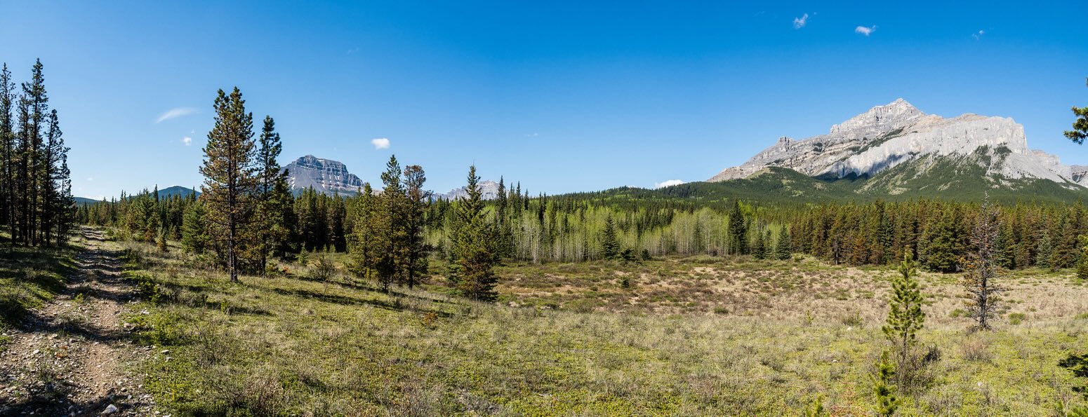
Once we finally reached the SE drainage leading towards Orient Point, it was already 2 hours into our trip. Conditions were perfect for the Ghost Wilderness Area with very little wind and only the occasional hint of a cool breeze. Birds were singing in the forest around us and the powerful scent of the pine and spruce trees wafted through the dead air. We ascended grassy banks on the north side of the drainage to avoid the loose boulders within.
Both Phil and I were starting to get slightly concerned about the complete lack of running water up to this point – we both needed to refill at some point on this hot day. I wasn’t overly worried as there were visible snow patches higher up. As we finally started gaining some height, we had a decision to make. We could either ascend the most easterly “Southeast Ridge” or a different one that was directly ahead – “South Ridge” on my map. We chose the south ridge since it looked to be the most direct from our vantage. This was a great choice and soon we were sweating our way up the steep grassy slopes and exiting tree line with views towards End Mountain and South Ghost Peak across the South Ghost River.

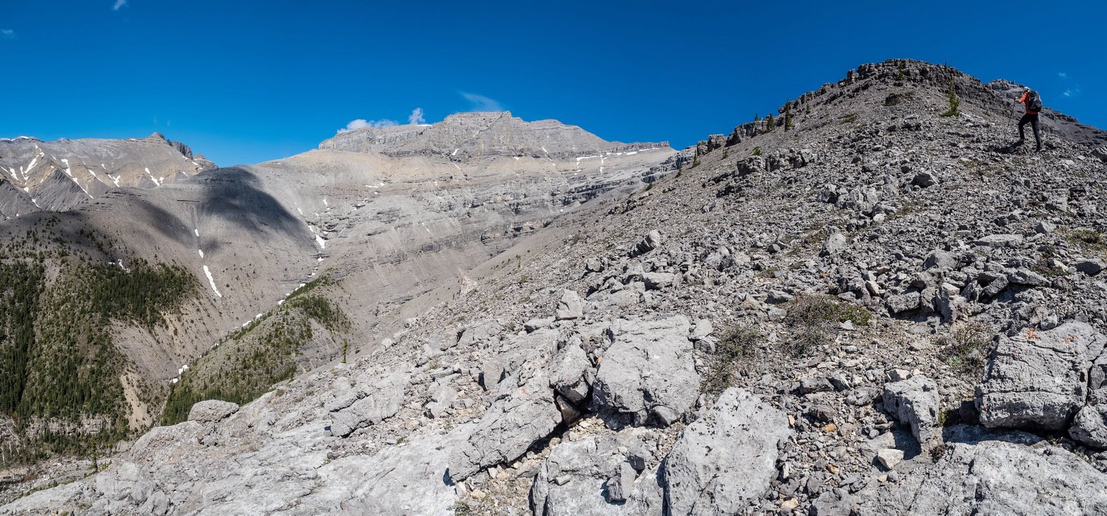
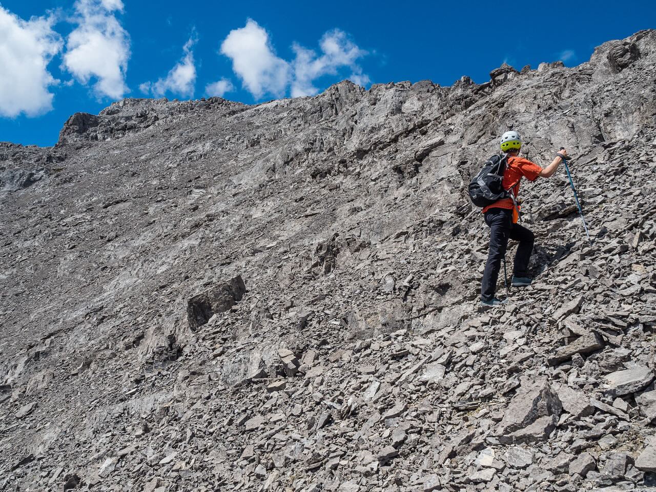
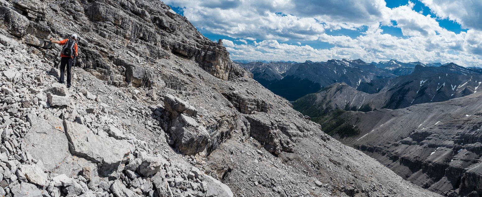
Once above treeline, we joined up with Phil’s previous ascent line and the interesting terrain began in earnest. As is the common theme on Orient Point, it seemed like we took the long way around to finally get onto the summit slopes – but in this case it wasn’t a bad thing. Our ascent route makes a lot of good sense beside just being fun and scenic – it’s also by far the most obvious of any of the other possible routes on the complex south side of the mountain. We simply ascended ridges until it made sense to traverse to the west (our left) before following more ridges. Along the way we passed by a nice rock window and the difficult route option through a tunnel hidden behind a huge chockstone.


We avoided the difficulties (we were in approach shoes and there was snow / ice in the tunnel) by going around a corner in the cliffs about 100m further climber’s left. A short moderate scramble brought us up to a large scree traverse towards the second moderate bit of terrain next to a patch of snow and leading to the scree / slab slopes just under the summit.

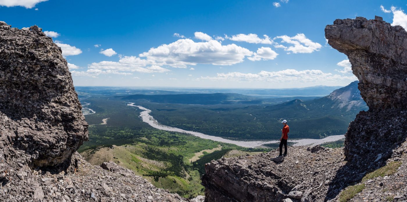
The slab / scree bowl just under the east summit ridge was far easier than it looked from afar. We trended climber’s right to keep the angle reasonable before cutting left on the exciting ridge towards the summit. The views from here were absolutely stunning on this perfect day! There was hardly a breath of wind as I followed Phil along the ridge, which narrowed considerably in places. Of course the summit was further than I thought – it’s never the closest high point is it? No matter, as the traverse was my favorite part of the entire day by far. We made the apex of Orient Point around 5 hours after leaving the truck and sat down for a nice lunch break to some pretty stellar views.


After enjoying the perfect summit weather and views for around 30 minutes or so, we decided we should start the long descent before anything cooked up in the clouds that were now forming above us. The descent ridge offered some fantastic views and photos and all too soon we were dropping into the slab / scree gully to the first set of cliffs – following our ascent route at this point. After plunge-stepping on snow through the first cliffs under the summit, we started deviating from our approach. It’s impossible to describe our route in any meaningful detail other than to say that we trended to our left (skiers), breaking easily through each subsequent set of cliffs until we got into the lower drainage. If the terrain blocked us we managed to escape each time by going up and around the head of another drainage before dropping back down into it.

Once we were finally in the main drainage, the exit was obvious and fairly quick. The terrain was very interesting with some fantastic, classic Ghost Wilderness views that you only get in this part of the Rockies. Cascading, clear water gathered in pools and cheerfully gurgled and bubbled down the rocky drainage beside us, offering much needed refreshment and a cool head-dunk. We passed some old ice flows before finally getting onto straightforward, easy terrain for the first time in several hours.
At this point the skies opened up temporarily and cooled us off a bit. All too soon we were back into hot, muggy conditions. We retraced our steps through the South Ghost drainage and enjoyed the easy hike (i.e. slog) back along obvious sets of tracks to the truck.


With the hot temperatures, it wasn’t a huge surprise when we drove back to the main Ghost River crossing only to see a faster and deeper current waiting for us. Several vehicles were parked on the far side under the Big Hill, so rather than spend more time getting nervous for the crossing, I simply drove into the river and crawled through it – much slower and more controlled than on approach. When the truck started slipping sideways in the strong current I gunned it a bit and popped over the far bank. PHEW. I likely won’t be crossing that river again until later in the year.

I enjoyed the scrambling on Orient Point. There are enough moderate sections and varied terrain above treeline to keep things fun and the exposed summit ridge has some ridiculous views. The hiking? Well… Obviously I’m no stranger to long approaches, and generally I find them cathartic with lots of time to think and chat and get into a different rhythm from everyday life. The approach we used wasn’t quite as scenic or engaging as say the amazing Castle Rock hike. I recommend approaching Orient Point via the open hills route and returning via the South Ghost River so that you don’t feel like you’re walking away from your objective for the first few hours!