
Elevation Gain (m): 750
Trip Date: July 25 2017
Trip Time (hr): 5
Total Trip Distance (km): 23
Quick ‘n Dirty Rating: Class 3 : you fall, you break your leg
Difficulty Notes: I still don’t know if there’s an easier way up or not but we were on trail and followed a ribbon up the headwall which led to the continuation of the trail. It was harder than Carnarvon Lake due to the lack of chains and exposure. Definitely harder than a hike or easy scramble.
Technical Rating: SC6; RE4
GPS Track: Gaia
Map: what3words
After a few intense days of backpacking and scrambling five summits, Kaycie and I were ready for a relaxing day by a gorgeous and remote backcountry lake. So that’s exactly what we did. When doing research for our trip, I’d relied heavily on Matt Clay’s August, 2015 trip where he and Sandra backpacked into Weary Creek Gap before traversing up and over Mount Muir before being turned back at the Carnarvon Lake chains. I had changed things up, based on his experience, choosing to ascend, rather than descend the chains. Since our original plans called for a much longer trip, I was keen to extend ours by at least a day and came up with an intriguing option to spend a day and night camping at Lake of the Horns (LOTH) from our Weary Creek headwall bivy.
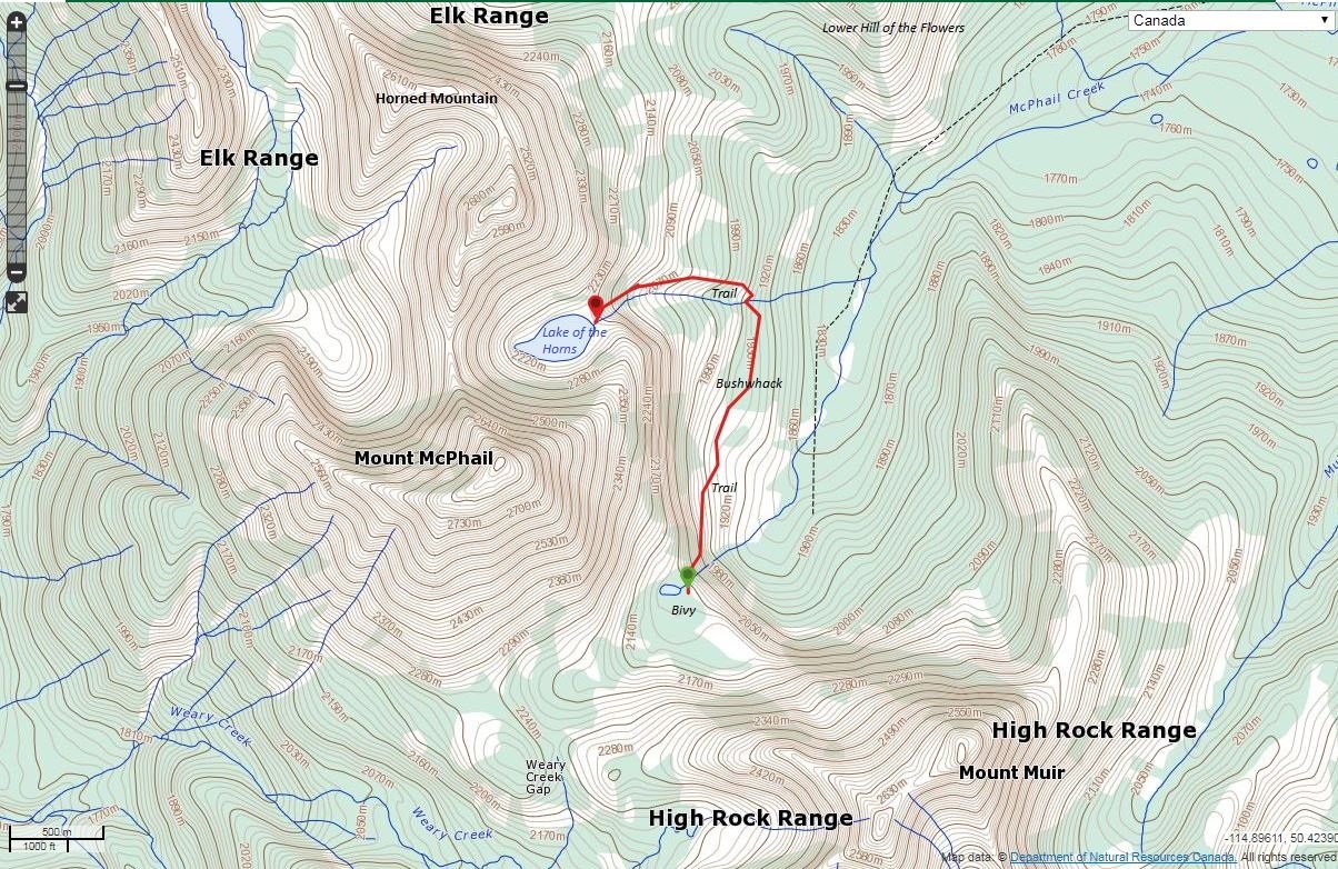
When doing research, I discovered that very few people actually bivy at LOTH. I’m not sure why, but all the trip reports I found, indicated a much lower camp along McPhail Creek instead. I didn’t see any reason why this had to be the case. Part of our exit day was going to be using the rumored horse track deviating north off the LOTH approach trail before looping back east towards Hill of the Flowers. We would ascend the steep (but easy) west aspect of Hill of the Flowers with our big packs before descending the normal route down the south ridge to the McPhail Creek egress trail. So far our plans had worked out perfectly and the weather couldn’t have been better. This positive trend continued. I knew there was a smattering of trails down from Weary Creek Gap’s headwall. The issue with most of them was that they went too low along McPhail Creek. We would explore a bit higher and hope for the best.
After packing up camp (slowly – there was no rush today), we picked our way down the headwall, following the route I’d discovered the evening before. As Sonny Bou found out, crossing the outflow stream near the lake from the Weary Creek Gap trail is nigh impossible thanks to the terrain and thick alders and willows. Descending along the south side of the creek looks hopeless at first, but there’s a hidden crossing that is simple, dry and right on the trail if you look for it. Easy peasy. After this crossing the trail descends steep terrain before finally exiting in delightful, flowery alpine meadows high above McPhail Creek. We followed an obvious trail north across the meadows before it slowly started to fade out.

From where the trail first faded out, we kept trending north towards the LOTH outlet stream. We knew we couldn’t get lost as long as we maintained this heading, but things did lapse into pretty thick bush for a few minutes here and there. Nothing too desperate but not 100% pleasurable either. Definitely worth not descending 100’s of vertical meters down McPhail Creek though! Eventually, by some minor miracle, I led us directly down a sheep trail into the steep LOTH outlet stream drainage. From here there was another track up the even steeper opposite side, leading right to the well-worn LOTH approach trail on the north side of the creek. Things were really working out for us on this trip! The sun was hot as we slowly made our way up the steep approach trail to the LOTH headwall.


The headwall started out innocent enough. I wasn’t concerned at all with it, since I knew it was in Daffern’s hiking guide. I also knew that Sonny Bou had done it and I didn’t remember anything extraordinary in his report either. Part way along the trail all of a sudden I noticed how exposed we were to the left. Dang! Not a huge deal, but a slip would be near fatal at this point. I cautioned KC and kept going along the trail. Soon things got even more exposed and the trail ahead wasn’t obvious anymore. I could see a possible route continuing on the opposite side of the outlet stream, but no obvious cairns or trail marking it. I looked up some very steep slabs above us and sure enough – there was a bright pink ribbon on a tree about 10 meters up indicating the continuation of the trail. Hmmm. This section was certainly doable, but it was steep and slabby – thankfully the grippy kind. I can’t say it was easy scrambling either, as a slip would be near fatal for sure on this section. Once again – watching KC ascend was nerve-wracking for me, but I knew I could guide us carefully back down as long as the slabs were dry and we took our time. Hikers who don’t like exposure should think twice about ascending this headwall – unless I missed a much easier option!
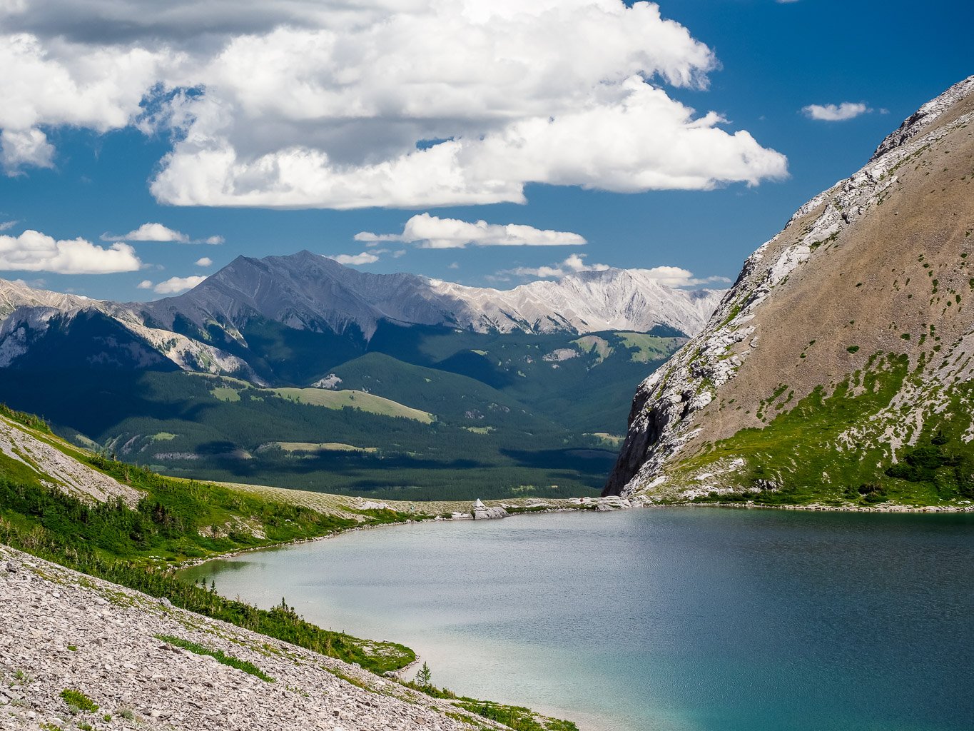
Once up the exposed bit of headwall, we found ourselves back on an obvious trail through a short forested section. After this it was a steep grunt up a trail in scree before yet another, slightly less exposed, slab traverse (requiring a tree to get up the first part) and we were finally up the headwall and at the mythical lake! All I can say is that on a gorgeous summer day like we had, LOTH is a magical place to spend a day. We set up camp on a perfect spot just east of the lake. It was very exposed to wind, but thankfully the winds were forecast light for the next day or two and we welcomed some breezes to keep the ferocious biting insects at bay.

We spent the rest of the day (it was only around noon when we got there) reading books and exploring the area. I walked around the lake, enjoying the north side much more than the steep, rubbly, loose south side. Hundreds of Cutthroat Trout were extremely active all day, making me wish for the second time this trip that I’d done a bit more research and brought my fly rod along. I’ll be back with it for sure someday. I was nervous enough about the headwall we’d ascended that I also spend an hour or so scouting an alternate route for the next day. Thankfully I found one, following sheep trails along steep cliffs to the north of the hiking trail. The terrain was still moderate and exposed along the ungulate’s route but shorter and easier to navigate with a big pack.

Since the sky was forecast clear for the night, I set my alarm for 02:00 and struggled out of my warm sleeping bag to an incredible star-filled sky. I spent an hour or so marveling at the heavens before dropping back down to the mid to catch a few more hours of blissful sleep.